Did you know scientists use different
lava textures to understand volcanoes on the Moon and Mars? A group of NASA and
university researchers are using roughness patterns of lavas on Earth to learn
more efficient ways to do just that. A recent Bulletin of Volcanology article by Whelley et al. discovered a way to separate different
lava textures based on roughness patterns in lavas in and around the Muliwai a
Pele lava channel in Hawai’i (Fig.1). Results from this study can make
distinguishing the distribution of lavas on the Moon and Mars more accurate and
efficient, and thereby tell us more about how the surfaces of those planets
formed.
 |
|
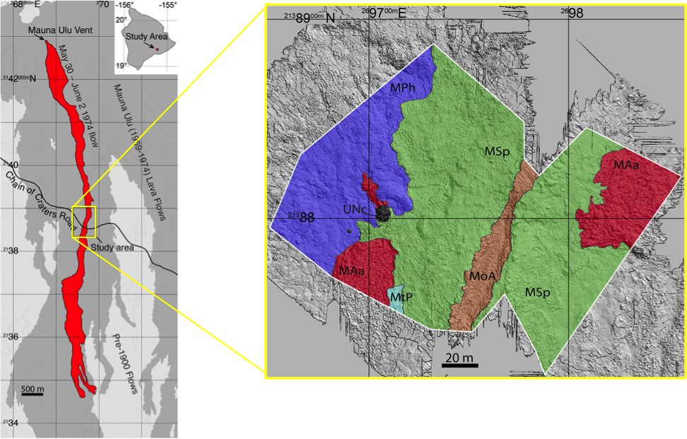
Figure 1. The image on the left is a map of Mauliwai a Pele lava
channel in red with an enlarged map of the study area to the right. The
different colors on the map to the right represent different lava units. Figure
modified from Whelley et al. (2017).
|
The
research team used LiDAR (light detection and ranging) data to make elevation
maps of their study area. Similar to how bats navigate by sending out sound
waves and listening for how quickly the sound returns, LiDAR sends out laser pulses
and measures how long it takes for them to reflect back to the source. From these
LiDAR derived elevation maps, the researchers found a new way to distinguish
lava types based on roughness patterns by using
a series of mathematical equations. They used these equations to automatically
separate jagged a’a textures from the smooth pahoehoe textures with 95%
confidence (Fig. 2).
 |
|
Figure 2. The left side of this image shows the smooth ropey texture
of a pahoehoe lava, while the right side shows the rough and jagged texture of a’a.
This image was obtained from the Atlanta Astronomy Club
and was taken from Hawaii Volcanoes National Park.
|
The moon and Mars are covered in ancient lava flows. The surface expression of these lavas or their texture can reveal information about the ancient volcanoes that put them there. For example, a’a is a result of high lava flow rate, while pahoehoe is created from lower flow rates. Therefore, by mapping these textures using roughness patterns and automated techniques, scientists can more quickly learn about the eruption history of volcanoes. Developing these techniques are particularly important when field-based mapping is difficult, impossible, or impractical, and mapping large areas at a distance is the only option such as on the moon and Mars.
Whelley, P. L.,
Garry, W. B., Hamilton, C. W., & Bleacher, J. E. (2017). LiDAR-derived
surface roughness signatures of basaltic lava types at the Muliwai a Pele Lava
Channel, Mauna Ulu, Hawai‘i. Bulletin of Volcanology, 79(11),
75.