The surface of the planet, also called the crust, is made up of ~20 plates that each move differently. These plates are always moving, frequently changing direction and speed. In modern times we can use GPS to measure plate motion. Interpreting past motion of the plates is much harder, and requires geologists to use other tools; one of the techniques that they use is to study hotspots and their resulting volcanoes.
Hotspots are located in the mantle, below the Earth’s crust (Figure 1). Like their name implies, these are areas of particularly high heat that melt the plates above them and can form volcanoes. Some familiar examples of hotspots are the ones beneath Hawaii, Yellowstone, and Iceland. A cool thing about hotspots: they don’t move. This means that as a plate moves above them, the hotspot just melts a different part of the plate. This creates chains of volcanoes, like we see in Hawaii (Figure 2). Hawaii is located on the Pacific plate, the largest plate on Earth, which is currently moving to the northwest. Right now the hotspot that formed the Hawaiian islands is located beneath the south side of the island of Hawaii (the Big Island). As you go from southeast to northwest, the islands get older and older. Hawaii is part of the Hawaiian- Emperor Seamount Chain, which goes all the way from Hawaii to Alaska. Each island and seamount (submarine volcano) on the chain was once on top of the Hawaiian hotspot and then carried away by the Pacific plate.
Hotspots are located in the mantle, below the Earth’s crust (Figure 1). Like their name implies, these are areas of particularly high heat that melt the plates above them and can form volcanoes. Some familiar examples of hotspots are the ones beneath Hawaii, Yellowstone, and Iceland. A cool thing about hotspots: they don’t move. This means that as a plate moves above them, the hotspot just melts a different part of the plate. This creates chains of volcanoes, like we see in Hawaii (Figure 2). Hawaii is located on the Pacific plate, the largest plate on Earth, which is currently moving to the northwest. Right now the hotspot that formed the Hawaiian islands is located beneath the south side of the island of Hawaii (the Big Island). As you go from southeast to northwest, the islands get older and older. Hawaii is part of the Hawaiian- Emperor Seamount Chain, which goes all the way from Hawaii to Alaska. Each island and seamount (submarine volcano) on the chain was once on top of the Hawaiian hotspot and then carried away by the Pacific plate.
 |
| Figure 1: Diagram of an hotspot (WIkimedia: Los688, 2008). The mantle is shown in red and the lithosphere in yellow. The upper yellow layer is the crust (i.e. the plate) |
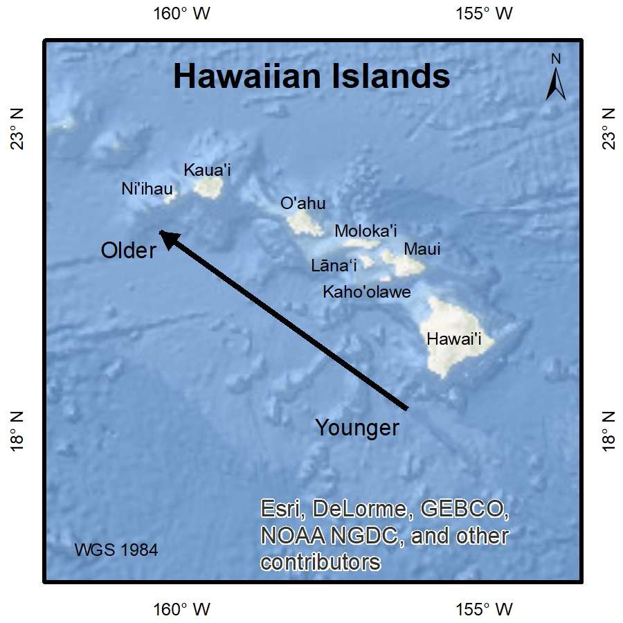 |
| Figure 2: Map of the Hawaiian islands. The arrow shows the northwest direction of plate movement. The islands become progressively younger from the northwest to the southeast. |
The Hawaiian hotspot is only one of several hotspots on the Pacific plate, which helps geologists more accurately understand how the plate has moved over time. Hotspots generally stay in the same place in the mantle over time, but they do move a little bit. This means we get the best measurements of plate movement when we can look at several hotspots, since one might make it look like the plate is moving faster or slower than others. We can compare the relative distances between hotspots over time to hone in on exactly how fast and in which direction the hotspots and plates are moving over time. Konrad et al. (2008) did exactly that by looking at the relative distances between the Hawaiian, Rurutu, and Louisville hotspots at different times in geologic history (Figure 2). They did this by using argon dating to identify rocks that are the same age from each hotspot and compare their locations by looking at the latitude they were erupted.
| Figure 3: Figure 1D from Konrad et al. (2018), showing the locations of the Hawaiian, Rurutu, and Louisville hotspots. The stars indicate the current location of the hotspots and the lines show their traces beneath the Pacific plate. The dashed lines (a, b, c) show an example of the measured distance between the hotspots.The yellow arrows point the the approximate locations where each chain is dated between 50-60 Ma. |
They noticed that the hotspots moved differently from each other between about 60-50 million years ago: the Hawaiian hotspot moved around 640 kilometers away from the Rurutu and Louisville hotspots during that time. During that same time the Ruturu and Louisville hotspots stayed about the same distance away from each other. There were three possible explanations for this. Either (1) Rurutu and Louisville hotspots both moved at the same speed away from the Hawaiian hotspot, (2) the Hawaiian hotspot moved away from the other two while they stayed in the same place, (3) or a combination of both. Because the hotspots are independent of one another, the authors believe that it less likely that two hotspots would move rapidly in tandem, and so they concluded that the best explanation is that the Rurutu and Louisville hotspots were relatively stationary during that time and the Hawaiian hotspot is the one that moved.
This means that the motion of the Pacific plate relative to the Rurutu and Louisville hotspots might give us a more accurate measurement of the speed that the Pacific plate moved to the northwest during the time between 60-50 million years ago. Because the Pacific plate is Earth’s largest plate, the better we can understand its past, the better we can understand geological phenomena related to its movement around a huge area of the planet during that time, such as volcanism in western North America and the Aleutian Islands. Though this doesn’t dramatically change the way geologists think about the Pacific plate, it does help provide a clearer picture of Earth’s geologic history.
It’s really a big deal that the hotspot moved, and so this is exciting news. This means that the locations of hotspots aren’t as locked in as it was previously thought. This challenges something that has been taken as a paradigm for geologists. This creates new opportunities to improve our understanding of our planet and raises new research questions about how hotspots behave and about the Earth’s mantle.
References:
Konrad, Kevin, et al. "On the relative motions of long-lived Pacific mantle plumes." Nature communications 9.1 (2018): 854. https://www.nature.com/articles/s41467-018-03277-x
Los688. "Hotspot Geology." Wikipedia: The Free Encyclopedia. Wikimedia Foundation, Inc., 24 August 2008. https://upload.wikimedia.org/wikipedia/commons/7/77/Hotspot%28geology%29-1.svg