Showing posts with label surface water. Show all posts

Tuesday, October 2, 2018

Buried liquid water on Mars?


The question of whether there is water on Mars has been hotly debated for decades. It has generally been proven that water exists on Mars, though it’s mostly trapped in its ice form. For life to exist as we know it, liquid water is a vital component. Because Mars has such a thin atmosphere, liquid water on the surface isn’t stable and will immediately boil off. This makes it very tricky to even begin to try to observe liquid water. Recently however, using radar instruments, Italian researchers have discovered evidence of a large, liquid water lake beneath the glaciers at the southern pole of Mars.

Aboard the EU’s Mars Express spacecraft is a special instrument called a radar sounder. Radar sounders work by shooting specific frequencies of radar pulses at the surface of a planet and then observing the reflected signal. This can be thought of like clapping in a cave and listening to the echo that comes back to you. Depending on what the echo “sounds” like, scientists can gain a wealth of information about whatever surface they aimed the instrument at. Differing frequencies used by the instrument contain information about the surface rock, ice, or even what lies beneath the surface.


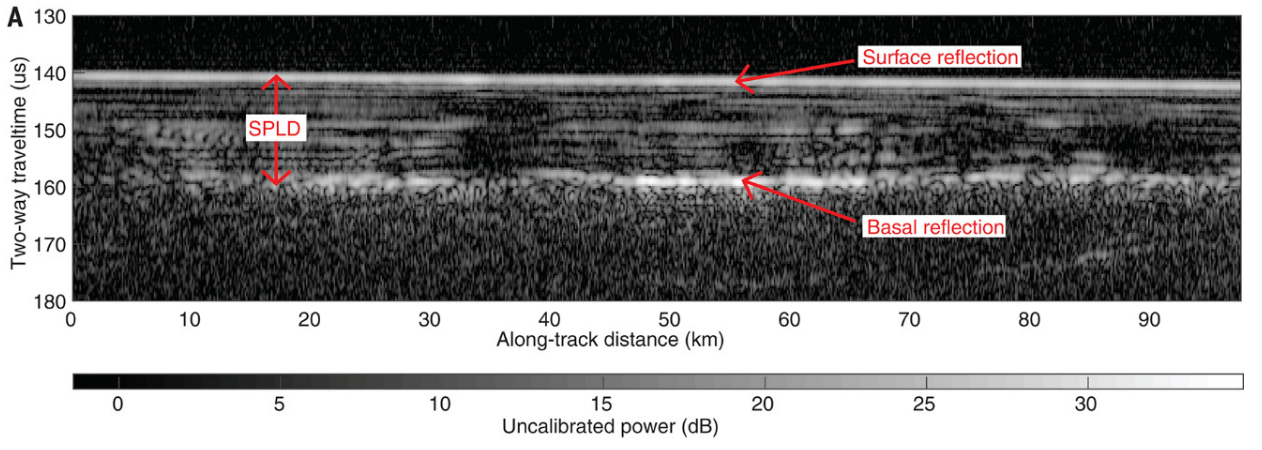
Figure 1: Radargram of the subglacial lake. In this figure, the x-axis is horizontal distance on the planet, and the y-axis is the time is takes the radar signal to bounce back to the spacecraft, which can be interpreted to understand subsurface topography. This figure can be thought of as a cross section. The subglacial lake can be seen at the basal reflection label. The SPLD label shows the South Polar Layered Deposit, which is an area of the south pole where pure water ice is formed in layers. Figure 2A from Orosei et al. (2018).

Using a radar sounder named MARSIS, Italian scientists made several flybys of the south pole region, which is mostly covered in water-ice glacier year round. What they found were bright subsurface radar reflections where, ordinarily, there should be nothing (fig.1). When you shoot a radar wave at a material, the target’s atoms will react by becoming electrically polarized to varying degrees (the atoms will have one side become more positive than the other, or vice versa). This degree of polarization can be unique for different materials, so it’s a great way to identify materials hidden in the subsurface. This quality of materials is known as dielectric permittivity. By analyzing the MARSIS radar reflections, the scientists discovered that the dielectric permittivity of the anomalous reflection matched that of water-bearing materials. By making several flybys of the area, the scientists were able to map out the subglacial lake and found it to be about 20 km wide and approximately 1.5 km beneath the surface (fig.2) 
Figure 2: This image shows the estimated size of the lake. Radar tracks are colored depending on subsurface elevations with warmer colors corresponding to higher elevations and cooler corresponding to lower elevations. The perceived lake is marked by the bold, black line. Figure 3A from Orosei et al. (2018).

Does this confirm that there’s a subglacial lake at Mars south pole? It’s very likely. (SHARAD, another radar sounder orbiting Mars, didn’t see the lake, though this may be to due to the different set of frequencies SHARAD uses). Does this confirm that there’s life on Mars? Not yet. For all we know, the lake could be completely inhospitable, or might not even be there in the first place! What this study does provide is compelling evidence that the secrets to extraterrestrial life in our solar system might be hiding under some ice, just one planet away!


Orosei, R., Lauro, S. E., Pettinelli, E., Cicchetti, A., Coradini, M., Cosciotti, B., … Seu, R. (2018). Radar evidence of subglacial liquid water on Mars. Science, 361(6401), 490 LP-493. Retrieved from http://science.sciencemag.org/content/361/6401/490.abstract


Monday, April 24, 2017

Colloquium Recap: Caitlin Rushlow

The rise of greenhouse gas concentrations in the atmosphere and subsequent increases in global temperature is disproportionately affecting the Arctic, as excess heat is driven polewards. As has been observed and predicted globally, this is leading to an amplification of hydrological cycle – manifested as increased river discharges in the Arctic (see Figure 1). These landscapes, which maintain intermittent and perenially frozen substrate known as permafrost, are highly sensitive to these changes. Our very own PhD candidate, Caitlin Rushlow, took to explain that in light of these rapid changes – how does hillslope form influence thermal and hydrological behavior of the Arctic landscape?


Figure 1. Large increases in poleward heat flux are already amplifying runoff response in the Artic. 

To do this Caitlin set up monitoring stations to build time series of soil temperature, water discharge, and water table depth in what are known as water tracks – zero-order basins which intermittently drain water off of Arctic hillslopes. Central to the understanding of how hillslopes produce runoff in response to precipitation is what is known as the “fill-and-spill” hypothesis (see Figure 2). This is the idea that after a certain threshold is exceeded during a precipitation event (or series of them), saturated zones on a hillslope will become connected and produce a punctuated runoff response.


Figure 2. Fill-and-spill hypothesis showing increasing connectivity of saturated zones over a storm event that drives intense runoff response.

What Caitlin found during summer monitoring periods was that water track discharge responded strongly to rainfall events, though not as rapidly as had been suggested in previous studies. The “fill-and-spill” concept seemed to definitely be at play here – strong hydrograph response was only observed after a certain amount of precipitation and water table rise was achieved (see Figure 3). The longer tails of these hydrographs during the spilling phase of these responses also seem to suggest that water tracks are the source of extended streamflow, once thought to be driven by slow hillslope drainage. 


Figure 3. Paired precipitation and runoff time series for a water track and resulting response model.

In order to tackle questions of how water tracks influence the depth and persistence of permafrost on Arctic hillslopes, Caitlin took an approach that used both field data and also utilized a robust hydrologic model to understand the advective versus conductive transfers of heat on hillslopes. What she found through geophysical surveys was that the depth of thaw was greater in water tracks relative to intra-track topography. Based on soil temperature profiles, the timing of permafrost thaw varied greatly between water tracks and adjacent hillslopes. Water tracks appear to both thaw and freeze later in the year than surrounding hillslope domains. This is important to the exchange of materials and biotic cycling that occur within these soil profiles. Finally, Caitlin’s modeling approach showed that advective heat transfer (i.e., the direct movement of heat) could greatly increase summer substrate temperatures (see Figure 4). Water and its transmission of heat in a historically icy landscape could have profound impacts on how this landscape will evolve into the future.


Figure 4.  Advection of heat in water tracks in model runs appears to amplify increases in summer temperatures in water tracks
We appreciate Caitlin’s fantastic science that is highly relevant to understanding the hydrology of sensitive landscapes as well as being a motivated spokesperson for our science community!

-Recap by Jimmy Guilinger